 We are honored to have Chelsie Jolley share her experience and knowledge of Geocaching with students. This post was prompted by our Meet a Tech Savvy Teacher section of our podcast. The full video interview is located at the end of this post. Enjoy:
Geocaching is a great way to both encourage students to be active in the outdoors and enhance students’ learning outside of the classroom! Geocaching is a modern day treasure hunt that uses GPS technology to bring someone to a certain location. Typically a container is hidden at this location with various contents.
My adventures geocaching with students began while teaching first grade. When I introduced my first graders to geocaching, I began by introducing compasses. We would practice using them, sometimes make our own, label the walls of our classroom with the cardinal directions, and even explore our playground to identify landmarks for each direction at our school. For my students in Helena, Montana, they knew that if they wanted to go north, they should follow “The Sleeping Giant” – a mountain formation visible on the horizon. Here in Minnesota, my students know the St. Croix River is to the east.
These lessons tie in nicely with geography standards. We used our walls in the classroom, labeled with cardinal directions, to play a game similar to Four Corners. Students liked using The Fruit Machine to help decide which wall would be selected. Eventually, the labels came down, and students had to first correctly identify the cardinal direction they were standing at before a wall would be selected. The game would also evolve into Four Corners, helping students correctly use the intermediate cardinal directions (NE, SE, NW, and SW).
After students mastered the cardinal directions, we would learn about maps. One activity my students really enjoyed is to make a map of our classroom together on a SMART Board and hide a geocache in the room. Several students would go into the hallway while the rest of the class helped hide the container and mark its location on the map. This was a perfect opportunity to teach students to use a tool to help you get close to your location, but then use your own eyes to find the container. A second rule we would practice is not to ruin the surprise for others. This helped reinforce patience among my students.
We typically then expand our mapping skills to our playground. Sometimes we also incorporate Google Earth to get a bird’s eye view of our playground or compare our maps. My third graders even create a scale for their maps. The past two years, we have done an activity using our scales to find locations on our playground using the maps.
When students have mastered mapping skills, I usually teach students about latitude and latitude. We explore what coordinates are, comparing the coordinates of our school to other places and playing games like Battleship. Finally, I teach students how to use the GPS receivers. We then walk through a geocache together to make sure students know how to use the GPS receivers.
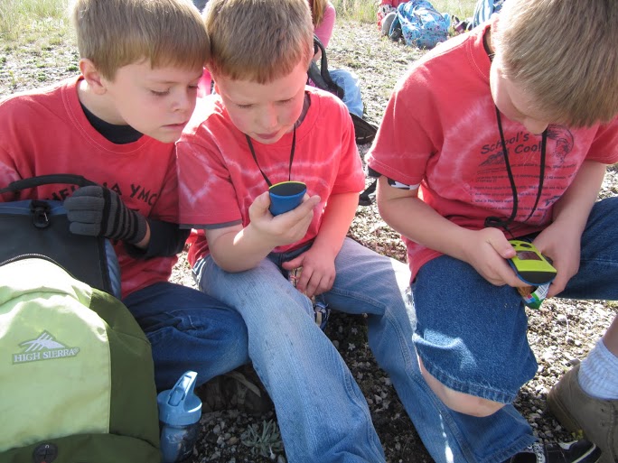
 After students practice using the GPS receivers in the large group activity, they are ready for geocaching in small groups. Everyone in the small group has an assigned role, which rotates after each geocache so that all students have a turn with each role. Some common roles I assign are navigator, seeker, reader, and recorder. The navigator holds the GPS receiver and is responsible for directing the group toward the geocache. The navigator walks first. All group members search for the geocache when the navigator indicates the geocache is within 20 feet. The seeker grabs the geocache once it is found, and hides it in the same spot when the group is finished. The reader opens geocache container and reads its contents. Finally, the recorder writes down the clue gleaned from the cache, or whatever information is necessary according to the geocache activity.
I typically make my own geocaches that are only used with my class. I mark coordinates on the playground and upload these locations to the other devices. I recommend procuring 5-10 GPS receivers for your classroom. I have had good luck with Geomate Juniors, as they are easy to program, easy to operate, and inexpensive. However, I recently received several Garmin eTrex, which allow my third graders to do more advanced activities, like hiding their own geocaches and finding the perimeter and area of our playground.
I integrate a variety of disciplines into geocaching activities. I often make the information from the geocaches a code for a padlock. This way, when the students return to the classroom, they can use the clues to decipher the password, unlocking a chest with a surprise in it. I also vary what is hidden at each location. Sometimes I hide a container, and sometimes I hide a QR code that needs to be scanned for further directions.
Here I list just a few of the many possibilities for enhancing learning through geocaching:
MATH
- Students use rulers to measure objects at locations
- Students read clocks and write down the times
- Level-appropriate word problems
- Level-appropriate calculations
READING
- Students create fractured fairytales
- Students read passages for the main idea
- Students sequence events
SCIENCE
- Students identify different trees, making rubbings and describing leaves of each particular tree.
- Students describe and analyze soil samples. Would the soil here work well for planting? Why/why not?
 SOCIAL STUDIES
- Drop off classroom travel bugs into active geocaches with a specific mission. Use a travel bug log to map where the item travels and ask for photos of the travel bug’s new location to study the environment. When we did this, our travel bug went from Montana, all the way to Germany and Australia in just a year!
TEAM BUILDING
- Students collect pieces of a tangram at each cache, and assemble a tangram picture as a group at the end
- Students scan QR codes at each geocache with instructions for a silly photo they need to take
Not only can geocaching be beneficial at school, but I have even used geocaching to extend beyond the school grounds. While teaching first grade in Helena, my students and I made an annual field trip to the foothills of the mountains. Here, students would take turns geocaching as we hiked up to a lunch spot. In order to hike on the trails, students learned trail etiquette. We spent story time sitting in a circle and went on a nature scavenger hunt in small groups where students used digital cameras to “collect” the items. At the top of the path, the first graders took turns searching for a real geocache – one I had not created for them – and could take a prize from the cache. In addition to this field trip, I have often created a geocaching booth during school-sponsored family events. Families could borrow GPS receivers and go geocaching on the grounds. It has always been a big success!
Our Interview with Chelsie: